Located off the coasts of southern British Columbia, Washington, Oregon, and northern California, the Cascadia Subduction Zone spans 600 miles and harbors a dangerous megathrust fault where tectonic plates converge. These plates can lock up and release stress, resulting in powerful earthquakes and massive tsunamis over 100 feet high. Scientists have been studying this area to understand its complexities and assess earthquake risks.
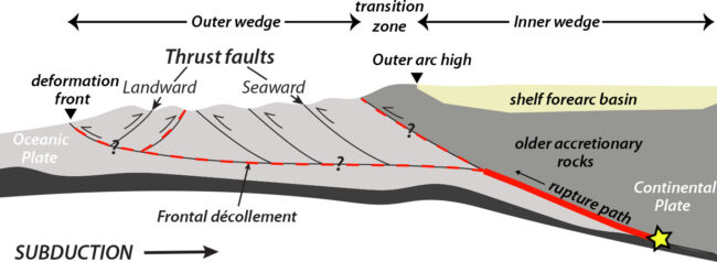
A recent study conducted by researchers aboard the Marcus G. Langseth research vessel has provided a detailed survey of the subterranean structures in the zone. This groundbreaking research reveals that the megathrust fault is divided into at least four segments, each potentially isolated from the others. This new information challenges previous assumptions and provides a more accurate framework for assessing earthquake and tsunami hazards in the region.
The study indicates that segments of the Cascadia Subduction Zone are separated by buried features, such as faults, which may limit the extent of ruptures from one segment to another. The differing geological compositions of the North American plate also play a role in segmenting the fault zone. The study identifies a particularly smooth segment running from Vancouver Island to Washington state as one of the most dangerous sections, with the potential for a full-length rupture.
Furthermore, the research suggests that the shallow subduction angle in the Vancouver-Washington segment could lead to increased shaking on land, particularly affecting areas like Tacoma and Seattle. The data collected from this study will be crucial in informing future preparedness efforts, including updating building codes and tsunami hazard assessments. With more research underway, scientists aim to provide practical assessments and recommendations based on this newfound understanding of the Cascadia Subduction Zone.